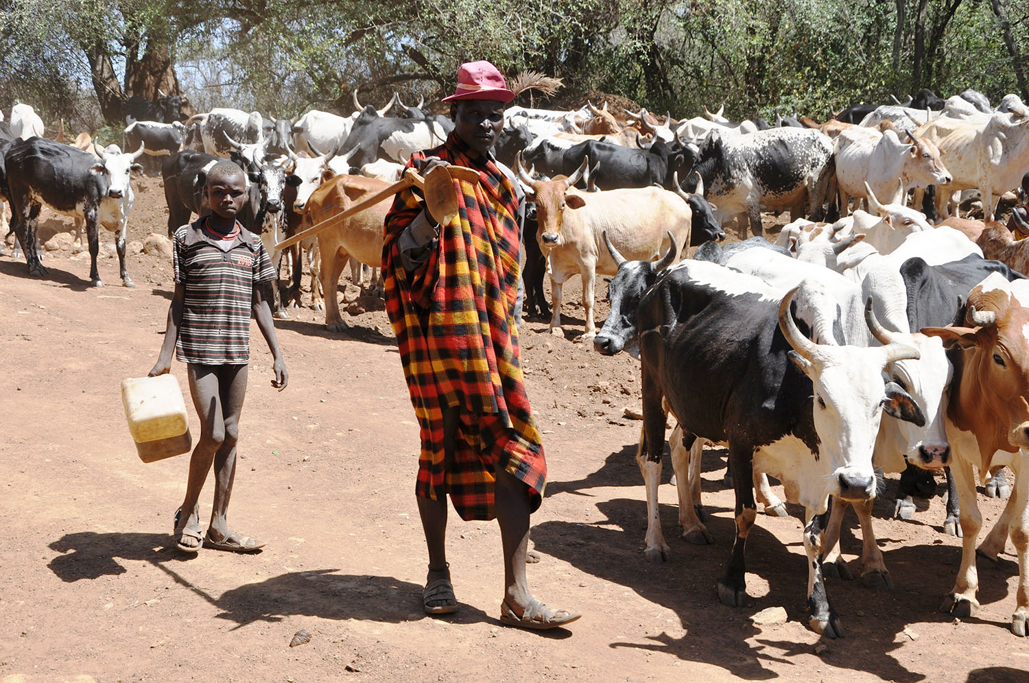
Aston Kamugisha was pensive and anxious. For two days, his herd of cattle had not got enough water to drink. Grass was also scarce. The scorching sun had gradually turned the once green, lush grass into a yellowish dry maze that his cattke did not want to eat.
He whistles, loudly that all the over 100 animals stand on attention. He then shouts some commands in ‘cattle’ language and the cattle start grazing again.
Kamugisha then boasts that the cattle are his family.
“I know them by the pet names that I gave each of them. They react when I mention their pet names,” he says.
The big stock has Rugaju and Bitanga, for example. Now seated under a short tree in Lwamata, 60 miles away from Kampala and 20 miles before Kiboga town, Kamugisha had been on the move for the last one month.
Together with a group of other herdsmen, they moved from Ssembabule, into Gomba and entered Mubende, just behind Lake Wamala. They then crossed the Mubende-Mityana road around Kiganda, before reaching Lwamata. They crossed into Ngoma through Kyankwanzi up to River Kafu on the Kampala-Gulu road.
“We sometimes graze through this area up to River Kafu,” he says. To reach Kafu, they graze through what is commonly known as ‘Lukoola’ in Nakaseke/parts of Kyankwanzi.
“That can take us around two weeks,” he says.
Some of his colleagues cross River Nile, by hiring trucks with their cattle and enter into lower Lango areas, then into Teso through Amolator and Kaberamaido. Others go as far as Gulu, Lira and Amuru.
While they move within the cattle corridor in most of the west and central of the country, in the north they sometimes graze on people’s crop farms, hence turning into a menace to other farmers.
Kamugisha says some of the land they graze on outside of the cattle corridor is ‘bought’ or leased to them for a given period of time, but he also agrees that sometimes the animals tray and graze in people’s gardens.
On November 2,President Yoweri Museveni wrote to the Prime Minister Robinah Nabbanja, tasking her to make sure that the ‘menace of balaalo’ is stopped in northern Uganda.
“Those balaalo should be given two months to leave the whole north unless they prove that they fulfill these minimum conditions; lease or buy land, but also have it fenced securely before the introduction of cattle there on and with water on the land,” the President advised.
The status of cattle corridor
This area runs from the south-western part of Uganda, through Rakai, Isingiro, Kiruhura, parts of Mbarara, Ssembabule, Gomba, Mubende-especially around Kiganda, Kiboga (Lwamata area) Kyankwanzi, Ngoma in Nakaseke, parts of Masindi, Nakasongola, Teso and Karamoja.
It is called the cattle corridor because it is here that at least 80% of the cattle in Uganda are kept. On top of cattle, there are also goats and sheep. Out of an estimated cattle population of 15 million, 12 milion are found within the cattle corridor.
The corridor is largely flat, with short shrubs and a lot of grass. There are rivers and streams that dot it too.
According to researchers Daniel McGahey and Zoe Visser, livestock production is the dominant livelihood activity. Formerly open rangelands in the 1940s which were under extensive pastoralism, they were allocated to land owners on an individual household basis.
The allocation, according to another pastoralism researcher Frank Muhereza, started in the late 1950s and early 1960s when the government of the day allocated big chunks of the cattle corridor to big ranchers.
Muhereza says the purpose was for the ranchers to develop them into commercially viable beef and dairy production centres. At the time, individuals got areas ranging from 5 square miles of land. Government ranches like Sanga and Kisozi also got allocations. In total, around Ankole, 207 ranches of 5 square miles each were created and given to individual commercial farmers.
Under the Masaka ranching scheme, which mainly covered areas of present day Ssembabule district, around 100 ranches were created in areas of Lugushuru and Ntusi. Today, modern ranches like the famous Frank Farm, Rainbow Ranchers and Ssembeguya Estates are located within this area.
However, while the land was allocated, many people who occupied the ranches before they were handed out remained there as tenants. In Ankole, many of them, mainly Bahima, started using the ranches after paying user fees to the big farmers.
In the early and late 1960s, milk and beef production indeed increased. “Many of the big ranchers went ahead and introduced improved breeds,” Christopher Ataho, in Gomba says.
Improved dairy cows like the holstein friesian were introduced. However, production on the ranches within the cattle corridor started dropping during the 1970s as the political instability took centre stage. This is because most of the planned establishment of water dams, community spray races and improved pasture were not set up.
In 1981, when a new guerrilla war broke out, it was unfortunately centred around Singo and Ngoma, which had several big ranchers. One of the most prominent of these was Tom Kaya. A lot of the cattle on the ranches were eaten by both the rebels and the government soldiers. In his book Sowing the Mustard Seed, President Museveni prominently points out how the cattle helped the struggle, especially during periods of food scarcity.
However, ranches in other areas like Ankole, Masaka and Mubende remained untouched. When the NRM government came to power in 1986, the question of the ‘squatting herdsmen’ within the cattle corridor rose up again. The Government thus moved to repossess most of the ranches and redistribute them amongst the nomadic cattle keepers. Of course, this was not easy.
To start the process, the new government issued Legal Notice No.5 in 1988, that established a commission of inquiry to manage the re-allocation. Subsequently, the commission came up with two main recommendations. One was for the government to repossess land that had not been utilised by the original ranchers and to reduce the initial allocations from 5 to 3 square miles in order to accommodate more cattle keepers.
According to Muhereza, the government reasoned that if the land is redistributed, this will be a solution to the resource management problem in the corridor. But of course, the previous ranchers, who had got the ranches from the government in the 60s had to be compensated for the losses.
“The compensation was not for the land, but for the structures like water dams and spray races on the ranches,” he says.
By the early1990s, at least 62 ranches out of around 105, formerly owned by the big ranchers were re-demarcated to accommodate more of the landless herdsmen. Of course, the big ranchers also retained some of their parcels.
Additionally, some new but wealthy ‘cattle keepers’ also got land in Ssembabule and Kiboga/Kyankwanzi. Depending on the size of the herd, hundreds of individuals got or retained areas ranging from 30 hectares to 4 square miles.
With this re-modeling, cattle keeping became more settled mainly in the Ankole and Ssembabule areas, Ngoma and Kyankwanzi. There was a big move to keep improved breeds obviously for their commercial benefits among farmers in Ankole and Ssembabule areas, while the traditional cattle-for example the Ankole cattle were gradually reduced.
The number of cattle in the country rapidly grew from around 5 million in the mid-90s to over 15 million at the moment. This included improved breeds.
In Ankole and most of Ssembabule, the ranchers went ahead and paddocked their land for better management. They were wealthy enough to set up watering dams and spray races.
In the next part of this feature, we shall explore the challenges that came with increased production and how the water-pasture issue can be effectively handled

